|
Ganaraska Forest
- a history
of conservation -
"A people without the knowledge of their past
history, origin and culture is like a tree
without roots."
Marcus Garvey
"After
all, history
is life itself."
George
M. Wrong
|
Ganaraska History
On this page: a wilderness of
trees... First Nations ... First Europeans... Early
greenbelt idea (1908)... Guelph Conference (1941)... Ganaraska -
the first conservation model (1942)...Reasons Ganaraska selected
as first test site... World War II (1939-1945)...
Eldorado
Uranium Refinery...
Timeline... General Motors (military vehicle testing)...
Formation of Department of Planning and Development (1944)...
Conservation Authorities Act (1946)... Creation of Ganaraska
Forest (1947)... First Ganaraska Conservation area (Garden Hill)
Commemorative Memorial (1967) - Conservation Authorities of
Ontario... Summary
10,000 years
ago ...
Ten thousand years ago, the Ganaraska
watershed was an expanse of land that lay buried all year round in
ice and snow.
As the ice age came to an end, the
surface features of the moraine took shape, molded by the flow of
melting ice and water. Soon the land that had been buried in ice,
became a wilderness of trees.
First human occupation ...
The First Nations
were the first occupants of the Ganaraska watershed and included the
Hurons, Iroquois (Cayuga) and the Mississauga.
Ganarask� was the
first recorded name
of present day Port Hope,
Ontario.
Mostly forgotten, a hidden place known as Monkey Mountain in the
Town of Port Hope is
one of the most important cultural and natural heritage landscapes
in Northumberland County.
According to early
historical accounts and maps, Monkey Mountain was the location of a
village site of the Cayuga people of the Iroquois Confederacy.
Several early
French maps (Joliet, Franquelin, Raffeix, Bellin, Danville, etc.)
from the mid 1600's show the village named �Ganarask� (or close
derivation) at the site of modern day Port Hope - more than a
century before the arrival of the first fur trader, Peter Smith.
Ganarask� it was
the first recorded site of human occupation in Port Hope and
Northumberland County. In Ontario, Ganarask� was one of several
important sites when Ontario was a thick forest and the only road
was a foot-path.
T his
period of the French Regime was witness to the
colonial expansion of the Old World into New, the fur trading
ambitions of the Europeans, the workings of the Sulpician
missionaries and the strategic role the native people played in the
struggle between the French, British and Dutch for control of the
fur trade.
Ganarask� was more
than a Cayuga village, it was a trading and missionaries place.
Ganarask� was also located at the foot of the
Ganaraska historic trail which led from
the north shore of Lake Ontario to Rice Lake. It was also
the most used and shortest carrying
(portage) route to areas further north including
the Peterborough area
and northern interior (chain of Kawartha Lakes).
The Cayuga name meant
"People of the Great Swamp".
A
large marshland once existed by the mouth of Ganaraska River (which
disappeared soon after the 1829 incorporation of Port Hope Harbor
and Wharf Company).
The exact location
of Ganarask� remains uncertain but important clues are found in the
origin of the Monkey Mountain name. A well documented historical
legend describes:
�If you walked on
Monkey Mountain at night, you are followed by little red lights and
little children can be heard screaming and running around yet there
is no one there. This occurs around an area where the natives had
their longhouse.� (Port
Hope District Historical Society (PHDHS) Newsletter, September,
2015; Little Tales of Old Port Hope, 1966; Port Hope
Evening Guide series, 1965/66)
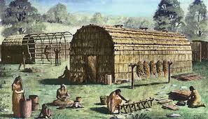
Sketch of
typical longhouse
The
Cayugas were known as �people of the longhouse" - a
longhouse would be evidence of a
village site. According to notes from PHDHS/East
Durham collection, the Monkey Mountain name may have been a change
over time from "Monk's Mound". The Sulpician Missionaries
from France were known visitors.
After Denonville�s
expedition in 1687 attacking the villages around Lake Ontario,
Ganarask� was heard of no more.
The late Ted Austin (1925-2001) who lived nearby on Cavan St.
reportedly uncovered local native burial sites and had the largest
known collection of artifacts found in the Port Hope area.
As mentioned above,
Ganarask� first appeared on several French maps from the mid 17th
century. J.N.B. Hewitt of the Smithsonian Institute wrote "Ganarask�
probably meant 'the spawning place', as this locality
was refuted too 'abound' in salmon." (Toronto during the French
Regime, 1933).
When control of
Canada passed from France to Great Britain in 1763, the French
Ganarask� name changed to "Ganaraska"
(the French letter "e" was replaced by the English "a")
from which
Ganaraska River is named.
Ganarask�
could have
become the only National Historic Site of Canada designated in Port
Hope (like a similar Iroquoian village by Rouge River in Toronto).
Extracts published in Northumberland Today
- March 8, 2017
First
Europeans...
In 1818, the Chiefs of the six Mississauga
tribes in this district gathered at Smith's Creek (now Port Hope)
and surrendered great blocks of land to the Crown for colonization
purposes. This tract comprised the modern counties of Victoria,
Peterborough, and, Ontario, Muskoka and Haliburton. Treaty #20 known
as "Surrender M" was comprised 1,951,000 acres. For this the Crown
undertook to pay �740 yearly in goods a the Montreal prices, or for
"every
man, woman and child the amount of 10
dollars (Spanish ) in goods, so
long as each child shall live but such annuity to cease to be paid
in right of any individual who may have died."
Port Hope was incorporated as a town in
1834 (population 1500 residents) - the first incorporated town along
Lake Ontario between Kingston and Toronto.
In 1856, the Grand Trunk Railway was
built and connecting Port Hope with Toronto and the east coast.
It's viaduct over the Ganaraska River was the second greatest
engineering challenge on the route (next to the bridge over the St.
Lawrence River at Montreal).
After the
first
Europeans arrived, the Ganaraska area which had been covered in
mature forests (pines and hardwoods) became severely
deforested.
Countless trees
were harvested for the construction of ships and ship
masts by the British Royal Navy. Agriculture (farming) which
followed the lumber industry caused further degradation.
With the forests chopped down and the lands cleared for farming by
the early 1900's, the conditions for flooding became acute in Port
Hope. Much of the region to the north became a wasteland area, with
desert-like sand dunes and washed-out gullies.
|
�In some parts of Ontario, the
trees, the soil and man�s livelihood were gone
with the wind by the early 1900s. Large tracts
of land that once supported thriving farms had
turned into empty wastelands�.
The Evergreen Challenge �
The Agreement Forest Story (Borczon 1982)
|
Until about 1860, up to 50 saw and flour mills
operated along the Ganaraska River. The mills drew farmers from up
to 60 kilometers away. Grain that could not be milled was
bought by up to five distilleries along the Ganaraska River who
produced the famous Port Hope whisky.
Effective conservation measures were desperately needed to
reverse the ecological damage that had swept areas of the province.
Re-establishing tree cover was important to preventing further
degradation.
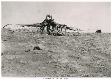
Ganaraska Wasteland Photo -- E.J.
Zavitz Wastelands #23
Photo courtesy of John
Bacher and Ed Borczon
E arly
greenbelt idea (1908)
From the late 19th century, Ontario
faced massive soil erosion, drought and major flooding problems
caused by extensive deforestation and poor land-management.
|
"Civilization has
now changed wide areas of this Province into a
land of cities and towns, large farms, huge
industrial plants, mines, and paper and lumber
mills.
This is a land largely denuded of its
forests; vast areas are eroded and unfit for
cultivation or any other purpose; many of its
streams are dried up, or polluted to the extent
they can no longer support aquatic life. In
Ontario, we are living dangerously � through the
heedless exploitation of natural resources."
Frank H.
Kortwright, 1940 |
The
first provincial nursery in Ontario was created in 1905 and
landowners were able to acquire trees at no charge. (This no-fee
service continued until 1980 when a nominal fee was introduced for
the trees).
The reforestation of the Oak Ridges Moraine,
including the Ganaraska Forest area, was first advocated by
E.J. Zavitz
in his 1908
Report
on the Reforestation of
Wastelands
in Southern Ontario.
|
"Extending through
Northumberland and Durham Counties is a sand formation
locally known as the "Oak Ridge" or "Pine Ridge"... It is
safe to say that seventy-five percent is wholly unfit for
successful farming... These areas should be preserved for
the people of Ontario as recreation grounds for all time to
come... The policy of putting these lands under forest
management has many arguments in its favour... It will pay
as a financial investment; assist in insuring a wood supply;
protect the headwaters of streams; provide breeding ground
for wild game; provide object lessons in forestry; and
prevent citizens from developing under conditions which can
end only in failure."
Report on the Reforestation
of Waste Lands in Southern Ontario,
1908,
E.J. Zavitz,
published by
Ontario Department of
Agriculture, Toronto |
Edmund John Zavitz (1875-1968)
was the first provincial provincial forester in Ontario.
More than any other man,
Zavitz
planted the first seeds of a modern day greenbelt plan more than a
century ago (see above)
Regarded as the Father of Ontario Forestry, to fellow foresters, he
became known as "E.J. - the foster father of a billion trees".
In
1935, he was appointed Chief of Reforestation. For many years,
Zavitz was also the boss and mentor of
A.H. Richardson.
In 1922, the Ontario government initiated the
Agreement Forest Program
with local municipalities which resulted in
treeplanting on over 110,000 hectares of marginal lands. While
much work had been done, it was still not enough to reverse the
environmental state of affairs:
|
"While much had been done, earlier approaches
were no longer adequate to both halt the
deterioration of the environment and the loss of
resources, and at the same time start to reverse
the trend of loss and decline. Blow sands and
windswept farm land were an increasingly obvious
problem. Springtime flooding and summertime
interruptions in water flow, the result of the
increase in population and of encroachment on
the flood plains of creeks and rivers, were also
becoming pressing issues... With so much
industry and growth, there was less and less
room for fish and wildlife.''
Ontario Federation of Anglers and Hunters |
The Ontario Conservation and Reforestation
Association was formed in 1936. A new reference point was �A New
Reforestation Policy for Ontario� by Watson H. Porter, managing
editor and published in the Farmer�s Advocate.
In 1938,
the Federation of Ontario Naturalists published a
study of the Oak Ridges Moraine, calling for its
reforestation. Public perception of forestry and
conservation began to improve:
"Never before in Canada has so much
interest been taken in the proper care and
development of our forests..."
(Forestry Chronicle Editorial,
1938)
Shortly
thereafter,
Ontario
became the first province in Canada to develop a
comprehensive conservation strategy
in the postwar era, beginning with the Guelph
Conference (1941).
Guelph Conference (1941)
On April 25, 1941,
concerned citizens and a group of nine organizations met to form the
Guelph Conference at the Ontario Agricultural College in Guelph,
Ontario on the conservation of the natural resources in Ontario.
The
Guelph Conference was organized by the
Ontario Conservation and Reforestation
Association
and the
Federation of Ontario Naturalists.
Other
organizations forming the group included the Canadian
Society of Forest Engineers (now the Canadian Institute of
Forestry), Royal Canadian Institute, Canadian Society of Technical
Agriculturalists, Canadian Conservation Association, Ontario
Federation of Anglers and Hunters, Royal Canadian Legion and Men of
the Trees.
A landmark series of conferences, studies, and
surveys which followed transformed the approach to conservation in
Ontario.
"The
gathering, which immediately became known as the Guelph Conference,
essentially marked the beginning of the conservation resurgence
in Ontario and, more importantly, provided momentum for the
conservation movement well into the postwar era."
Steve Jobbitt, (2001) p. 68
The Guelph Conference
lobbied the government based on the belief that:
"current management
practices could not adequately ensure a firm foundation on which to
build an economically prosperous Ontario ... reinforced by the high
frequency of serious flooding in the late 1930's."
(Johnson, 1964, p. 95; Reid, July 9, 1968, p. 3).
A fundamental concept was developed where conservation of natural
resources would be based on watershed, rather than political
boundaries. This watershed scope and municipal partnership
model would lead to the Conservation Authorities Act of Ontario in
1946. This new act led to the creation of 36 conservation
authorities across the province.
"...Natural resources form a delicate balanced system in which
all parts are interdependent and they cannot be successfully
handled, piecemeal."
(Professor A. F. Coventry quoted in Conservation by the People,
1974)
In August of 1941, the Guelph Conference committee met with the
Federal Committee on Reconstruction in Ottawa. Having a
positive response, it was agreed that federal funds would be
appropriated to assist in conducting a pilot watershed survey
in Ontario, so long as the survey constituted a
''special
piece of conservation research for application to
Canada."
(A.H. Richardson,
Conservation by the People, 1974, p. 14)
A follow-up report was issued
by the Guelph Conference
entitled
Conservation and Post-War
Rehabilitation
(1942) which confirmed the unhealthy state of natural
resources and recommended an integrated resource management planning
study of watersheds, particularly in Southern Ontario. The report's
conclusions listed the seriousness of many depletions observed:
water resources were drying up � 80% of the streams that flowed a
hundred years ago were now temporarily dry during the year (what
waters remained were largely polluted by industrial waste and sewage
waste from municipalities of all sizes); forest covers had
dangerously decreased; erosion by wind and water was on the
increase, soil had become impoverished through loss of fertility and
the impact of all of this was damaging fish and wildlife habitat and
population. The report emphasized the urgent need for an initial
conservation project to form the basis for general application
throughout the province.
It was argued that environment, economy,
and society would benefit from a management strategy which was
watershed based and considered renewable natural resources as an
integrated whole.
As well
as showing the need for conservation measures, it was suggested that
"the program would contribute to re-establishing people in civilian
life after their return from the war." (Guelph Conference, 1942,
Conservation and Post-War Rehabilitation, p. 3, Guelph, Ontario).
This program entitled "Conservation and Post-War Rehabilitation",
was presented to the Federal Advisory Committee on Reconstruction.
In 1942, the Government of Canada (Federal Committee on
Reconstruction) appointed a sub-committee on the Conservation and
Development of Natural Resources.
Headed by
Dr. R. C.
Wallace
(1881-1955), principal of Queen's
University, the sub-committee was directed to
"consider and recommend...
the policy and programme appropriate to the most effective
conservation and maximum future development of the natural resources
of the Dominion of
Canada".
Dr. Wallace's sub-committee was
also given the responsibility of identifying
"the importance of these
resources as national assets..."
(A.H. Richardson,
1974, p. 14)
The
Committee on Reconstruction informed the Guelph Conference that the
Federal Government was interested in any practical plan that
employed men and women after the war; the Guelph Conference
Plan was acceptable; a watershed site had to be recommended by
the Conference; and to avoid precedence, expenses of the survey had
to be shared equally by the Province and Canada (Thomas, J. D. 1966.
"The Guelph Conference", Watersheds, Vol. 1, No. 4, December, p.
10.)
A highly
esteemed educator and geologist,
Robert Charles Wallace took a much broader
approach to conservation than the prevailing soil restoration or
reforestation model of the time. What was really required was
a survey of
all resources
leading to
multiple purpose rehabilitation
- in essence the first model of a modern day greenbelt plan.
Dr. Wallace
had a special sensitivity to good conservation practices which
extended from the northern reaches of the watershed to the southern
edge of the Town of Port Hope where Eldorado Uranium Refinery was
located. He could not ignore the flooding problems in
the town and the potential threat to the world's largest uranium
refinery at the lowest elevation of the catchment basin. At the
exact same time of the Ganaraska study, Eldorado was acquired by the
Canadian Government and made into a crown corporation.
Following a
meeting in 1942 between the Guelph Conference committee and
Mitchell Hepburn, Premier of Ontario, an Interdepartmental
Committee on Conservation and Rehabilitation was formed by the
Ontario Government. A.H. Richardson (then a Forest Engineer with the
Department or Lands and Forests) was appointed full-time Chairman of
the newly formed provincial committee.
Ganaraska - the first conservation
model (1942)
In 1942, the
103-square mile [265-square kilometres]
watershed of the Ganaraska River, which enters Lake Ontario at Port
Hope, was selected for the pilot survey.
The Ganaraska Watershed
was chosen
to demonstrate the benefits of
conservation
in Ontario and as
an example of conservation study for all of Canada.
The
Ganaraska Survey
was conducted in the summer of 1942, and the report
published in 1943. The survey resulted in a new comprehensive
approach to conservation and covered extended to soils, climate,
vegetation, forestry, plant diseases, entomology, wildlife, water
flow and utilization, and the physical and economic aspects of
agriculture.
Ontario
went on to become a leader in conservation in Canada, spurred
largely by the fact that southern Ontario was one of the few areas
in Canada that by the late 1800s was so densely settled and its
resources so unwisely exploited that conditions matched those that
inspired the rise of the conservation movement south of the border.
For the first conservation model in Canada,
Ontario had to look south of the border in two places, The
Muskingum Watershed Conservancy District (MWCD) in Ohio and
the Tennessee Valley Authority (TVA). Both the TVA and MWCD
provided excellent models for the development of watershed
management programs in Canada in the postwar era, especially
in Ontario.
Dr. R.C. Wallace spent two weeks touring the
TVA in 1942 and was deeply impressed by how the federal
authority there had taken the responsibility "of bringing
back a large watershed to productive life" and saw in it
as a model for planning and development in Canada.
A. H. Richardson also personally organized at
least three official tours of the MWCD between 1948 and
1957.
R easons
Ganaraska selected as first test site
Any location could have been selected in
Ontario as the first test area - but the Ganaraska region
was chosen.
There are several probable reasons including:
- the size of the
watershed - the
watershed was small compared to most others
in Southern Ontario -
103 sq.
mi. (267 sq. km);
-
"a
complete group
of conservation needs
to develop." A.H.
Richardson, July 9, 1964 interview (Mitchell
and Shrubsole, 1992, p. 59)
-
quick elevation change of Ganaraska
River "rises in hilly country, most of
the streams drop very quickly in elevation
for the first three or four miles".
(A.H. Richardson. Ganaraska Watershed
Report, 1944, p. xii)
- history of severe
flooding
especially in the
Town of Port Hope,
primarily due to the rapid change
in elevation further north and the location
of Ganaraska River through the middle of the
town.
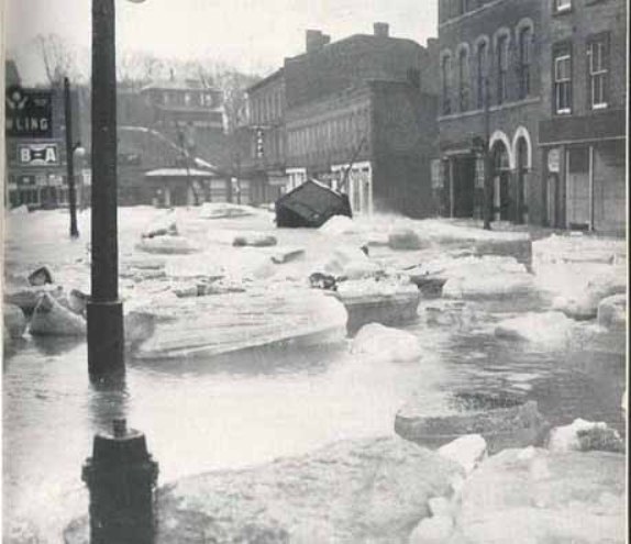
Flooding - Walton Street, Port Hope
The Ganaraska Watershed Report, 1944, p. 71
|
An
interesting historical account from the Port Hope
Evening Guide - Friday, July 13, 1883 and
the floodwater impact on the old Midland Railway Track
line through the Ganaraska area:
"Another heavy
thunder storm set in at noon Saturday. The water fairly
poured down and ran in rivulets on both sides of Walton
Street, large enough to float a boat in. The damage to
the crops in this vicinity is very serious.'
At Garden Hill a fearful storm was raging. The Midland
Railway Track was overflowed in several places to the
depth of three or four feet...(the train) proceeded
carefully... at the rate of four or five miles an hour.
When coming to a part of the track which was covered
with mud, sod and stones, six or eight inches through,
(it) backed up again towards Millbrook... Between those
two places (Millbrook and Garden Hill), it was found the
track had been washed away in several places.
At Deyell's crossing a hole on the travelled road had
been cut out eight feet deep, and railway ties had been
carried 40 rods by the flood and thrown on the track.
The storm did not last more than half an hour, and such
a downpour, has not been known in the memory of the
'oldest inhabitants'. The barley and fall wheat fields
are all flattened by it. The creek at Canton too is
overflowing the road. Such a thing has not been known
before, unless it had been blocked with ice." |
In modern times, the
frequency of flooding has been reduced after the channel through the
centre of Port Hope was deepened following the massive 1980 flood
which washed away some multi-story buildings over a hundred years
old.
- a devastated landscape
resulting from
exploitation of resources - "the
(Ganaraska region's) prosperous days of
lumbering, settlement and substantial
contribution to Canada's wealth are mere
history, although history is all too recent
in terms of the exploitation and exhaustion
of resources.�
(Dr. R.C. Wallace, Principal
and Vice Chancellor Queen's University -
Introduction in the Ganaraska Watershed
Report, 1944)
These factors however, were not exclusive to the
Ganaraska region. Timing provided another important clue - Canada
was in the middle of World War II.
World War II (1939-1945)
It is ironic that one of the
greatest conservation plans in Canadian
history occurred during the most destructive
armed conflict in human history
(WW II).
"The war
itself played a rather unusual but critical role
in the landmark series of conferences, studies,
and surveys that filled the next decade and
transformed the approach to conservation in
Ontario.''
Conservation 2000
- Chap. 5, p.75
The Toronto and Region
Conservation Authority
|
Canada was also committed to a policy
of 'total war' effort during WW II meaning all industries, materials
and people were required to be put to work for the war effort,
including GM in Oshawa when the production of all civilian vehicles
ceased and was replaced by military vehicles only.
With ever increasing sensitivity and security surrounding the
activities of Eldorado, the refinery was purchased by the Government
of Canada in 1942 creating Eldorado
Mining and Refining Limited, a Crown
Corporation.
The selection of Ganaraska as the first test area
was also probably influenced by the location of two major wartime
industries located nearby - Eldorado in the Town of Port Hope
and the military vehicle testing site of General Motors in
the rough hilly terrain of the northern reaches of the Ganaraska
watershed - usually at night under an envelope of darkness.
Eldorado Uranium Refinery
Since it's establishment in
the 1940's, Ganaraska Forest to the north has played an important
role for the Town of Port Hope
on Lake Ontario.
Eldorado
was situated at
the lowest elevation of
a town with a long
history of severe flooding problems.
The uranium in the world's first atomic bomb was refined at Eldorado
in Port Hope, Ontario (now known as Cameco).
Eldorado was
built on a floodplain and former swamp next to Ganaraska River at
the southern end of Port Hope
- the lowest elevation.
By 1932, Eldorado had set up operations here before
there were municipal building by-laws.
From 1932, the Federal Government had
repeatedly been warned of the dangers of radiation. Dr. Marcel
Pochon, the first manager of the Port Hope refinery, sounded the
first alarm bells in Port Hope in 1933 "Radium is highly
dangerous, the slightest fraction of a milligram taken into the
system leads to cancer, anemia and disease of the hip bones. Not a
doctor on earth can save the unfortunate person who is affected".
(Port Hope Evening Guide)
Between 1829
to 1844, the large swampland area was
dredged for a new harbour. By the 1950's, most of the
original buildings of Eldorado were removed.
The Canadian government
operating in total secrecy
(as owner of Eldorado - a crown corporation) had a
vested interest in a conservation plan that would alleviate flooding
risks and minimize future environmental damage. (Today,
it is recognized that nuclear wastes are potentially hazardous and enriched
uranium mixed with water could trigger a �critical,� or
self-sustaining, nuclear reaction.)
The Federal Government had an
interest in the Ganaraska Report - it helped fund the study.
Reforestation and other conservation measures upstream would help
reduce the frequency and severity of flooding downstream and
mitigate potential hazards associated with the Eldorado site,
particularly in extreme flooding events.
The same year Eldorado was acquired
by the Canadian Government (1942), the Ganaraska Watershed was
selected as the initial
test survey area, the only
test survey area, for conservation study funded
by both federal and provits in the same year with all resources
designated toward the war effort during a major war, were all
probably more than a co-incidence.
The atomic
bomb project of WW II was the largest secret operation in history -
code name the Manhattan Project.
The Manhattan
Project produced two of the most destructive weapons the world has
ever known - the Hiroshima and Nagasaki bombs (August, 1945).
With
the uranium supplied by the Canadians and Eldorado,
the bombings in Japan by the Americans marked the end of the war.
The greatest scientific project of
nuclear
research and development in Canadian history followed.
"Debate on the use of the bomb will continue but
it can be argued that
it brought the Second World War to a sudden end
and may have saved the lives of millions of people in so doing.
One of the incidental effects of this abnormal wartime programme
was the early involvement of Canada on a scale highly improbable
under other circumstances. The greatest scientific project of
research and development in Canada's history followed."
Hurst, D.G. et al
(1997) Canada Enters the Nuclear Age. p. 4
On October 11,
1945, Prime Minister MacKenzie King wrote in his diary:
"How strange it is that I should find myself at the very centre
of the problem, through Canada possessing uranium, having
contributed to the production of the bomb, being recognized as one
of the three countries to hold most of the secrets." (War Into
Cold War, p.159)
Without the
involvement of the Federal government in the major wartime industry
(and its ownership of Eldorado Refinery) and the initial Ganaraska
conservation study - historians may ponder whether Ganaraska
Forest would exist today.
While the U.S. has declassified
250,000 documents on its atomic weapons and energy program - Canada
has not been open. Further research is required.
Timeline
Within a narrow
time-line, the events leading up to the creation of Ganaraska Forest
during the war
years (1939-1945) were as follows:
-
Uranium refined by Eldorado,
Port Hope for the Manhattan Project - the largest secret project
in human history.
(From 1941 to
1945, the entire production of Eldorado was used in the
Manhattan project);
-
1941 -
Guelph Conference;
-
1941 -
Guelph
Conference committee meeting in Ottawa with Federal Committee on
Reconstruction;
-
Eldorado
Nuclear acquired by Canadian Government and made into a new
crown corporation;
-
1942
-
Interdepartmental Committee on
Conservation and Rehabilitation formed by the Ontario Government
;
-
1942 -
Ganaraska Watershed chosen as the initial test survey in Ontario
-
1943 - original report of
The Ganaraska Watershed delivered to Dana Porter, Minister of
Lands and Forests;
-
1944 - subsequent
publication of Ganaraska Watershed report;
-
the Hiroshima bombing in
1945 which effectively ended
the war.
General Motors
(military vehicle testing)
General Motors played a decisive part
in bringing WWII to an end.
With war looming in Europe, R.S. McLaughlin was asked
by the Department of National Defence if GM would be willing
to provide war materials if needed. GM quickly responded and began
building different types of army vehicles (trucks and tanks).
In 1942, the production of civilian
vehicles was brought to a halt to devote all production to the war
effort. Canadian industry produced over 800,000 military transport
vehicles for Canadian Forces and allies.
GM produced the
vehicles in Oshawa but needed somewhere to test them. A rugged
portion of the Ganaraska on the Oak Ridges Moraine was well suited
for the purpose and facilitated the testing of GM military vehicles
for the Canadian Army. The terrain was rugged, hilly, steep and
rather remote. Mr. Peacock, local resident and Father of Mark
Peacock (GRCA), still recalls the loud rumbling of heavy vehicles
heard regularly during the war - usually under the cover of
nighttime.
ATV enthusiasts are still attracted to the off-road
challenges of Ganaraska Forest today.
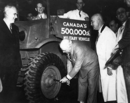
Col. Sam
McLaughlin
tightens the
last bolt on
Canada's 500,000th military vehicle for the
war (center)
Rt. Hon.
C.D. Howe,
Minister of
Munitions &
Supply
(left)
Oshawa
Public
Library
Local
History
Collection
The Ganaraska Watershed
survey (1942/43)
As a result of the Guelph
Conference, the Ganaraska
Watershed was chosen in 1942
as the first
test project in Ontario.
"The Guelph meeting gave
birth to an outstanding
project,
the
Ganaraska Watershed
survey,
jointly sponsored by
the government of
Ontario and the
government of Canada."
A.H.
Richardson, 1974, p. 105
The survey
work was conducted in the
Fall of 1942 and Spring of
1943:
"The work
in compiling the report
(Ganaraska), including
maps and photographs,
was done during the fall
of 1942 and the spring
of 1943. In this
work,
Verschoyle B. Blake
(and the
Interdepartmental
Committee) were of great
assistance..."
(A.H. Richardson (1974)
p. 16)
The
first edition of the
Ganaraska report was
published in 1943.
"On
June 15, 1943, the
original report of 450
pages of The Ganaraska
Watershed was delivered
by A.H. Richardson to
Dana Porter, Minister of
Lands and Forests (only
six copies of the
original full length
version were printed).
Porter complimented
Richardson on the survey
and said in his affable
manner, "Mr.
Richardson, this is a
classic."
(A.H.
Richardson, 1974, p. 18)
A
shorter abridged
version of The
Ganaraska
Watershed report
for public use
followed and in
1944 was
published by the
Ontario Ministry
of Planning and
Development
in two editions.
"Entitled The Ganaraska
Survey, the report was
unlike any other ever
produced by the Ontario
government, and
represented a
significant departure
from the way in which
resources were
traditionally regarded
in Ontario." (Steve
Jobbitt, (2001) p.74)
The Ganaraska
survey was seen as an
example of conservation
study for all of Canada.
The content of the Ganaraska
Study was seen by Dr. R.C.
Wallace of Queen�s
University as:
"general
significance for the
conservation and
rehabilitation of all
our resources throughout
Canada."
(A. H.
Richardson,
Conservation by the
People: The History of
the Conservation
Movement in Ontario to
1970, (1974)
As the first
test pilot area in Ontario,
Ganaraska led the way for
the development of watershed
conservation policies and
conservation authorities in
Ontario.
"While
primarily a study in
land use with plans for
the rehabilitation of
this particular
watershed during the
post-war period, the
Ganaraska Report would
become the
model
for future conservation
studies throughout the
Province of Ontario."
(John C.
Carter, Ontario
Conservation
Authorities: Their
Heritage Resources and
Museums, Ontario
History/Volume XCIV, No.
1, Spring 2002)
The most
important recommendation in
The Ganaraska Watershed
report was for the
establishment of a 20,000
acre forest.
"...
the most important
conservation measure
recommended is the
establishment of a
20,000 acre forest on
marginal and submarginal
land at the north of the
watershed..."
(A.H.
Richardson, The
Ganaraska Watershed
(1944) xv)
New concepts like the
ecosystem approach and
watershed planning were
formed and were two of the
most significant innovations
of the Ganaraska study.
The work of
three key individuals stood
out in The Ganaraska
Watershed report, including
Dr. R. C. Wallace
(1881-1955),
A. H. Richardson (1890-1971)
and V. B. Blake (1899-1971).
A.H. Richardson was given
the responsibility of
organizing the initial test
survey for the
Province of Ontario. Dr.
R.C. Wallace, Principal of
Queen's University wrote the
Introduction in the
Ganaraska report and was
actively engaged as the
central figure for the
Canadian Government.
Blake helped compile the
Ganaraska
Report
and was the only area
resident and historian on
the original survey team.
The book was
an immediate success and
considered a landmark for
the future of conservation
in Ontario:
"The
results of the survey of
the Ganaraska River
basin and
recommendations based
thereon, have recently
been published in a
report which may well
become a landmark in
Ontario Conservation
literature... The
general subject covered
by the report - the
condition of the soil,
water, woods, wildlife,
etc of a particular area
of agricultural Ontario
and recommendations for
its restoration based on
exact knowledge - is one
vital to the future
welfare of our
province..."
(A.H.
Richardson quoting Prof.
J.R. Dymond (1974) p.
17)
The Ganaraska
Watershed report proved to
be monumental, nationally
and provincially:
"the document proved
to be monumental in
terms of the resurgence
of the conservation
movement in Canada
generally, and in
Ontario in particular."
(Steve Jobbitt,
(2001) p.74)
The Ganaraska
Watershed report became a
model for future
conservation studies in the
province:
"While
primarily a study in
land use with plans for
the rehabilitation of
this particular
watershed during the
post-war period, the
Ganaraska Report would
become the
model for future
conservation studies
throughout the Province
of Ontario." (John
C. Carter, 2002)
|
"The conservation authority movement in
Ontario is world renowned,
and professionals and
parliamentarians from other
provinces, the United
States, the United Kingdom,
and other parts of the world
have come to study it.
Unique in Canada until 1970,
the program has proved so
effective that is now being
emulated in two other
provinces � Manitoba and
Quebec."
A.H.
Richardson,
Conservation
by the
People: The
History
of the
Conservation
Movement in
Ontario to
1970,
(1974)
|
The Ganaraska
Report (1944) identified a
number of projects which
should be undertaken. In
addition to the above noted
recommendation for
reforestation of 8,100
hectares (20,000 acres),
other recommendations
included:
-
new
legislation be enacted
"It soon became
obvious that the
Conservation Authorities
Branch was pioneering in
new fields. There were
no terms of reference,
no guide lines to
follow, and until a
conservation authorities
act was produced to
present to the
municipalities, the
branch was really not in
business."
(A.H. Richardson,
Conservation by the
People � The History of
the Conservation
Movement in Ontario to
1970 � (1974)
-
natural
land-use planning
borders
the use of natural,
rather than political
boundaries was one of
the most significant
innovations of the
Ganaraska study.
The
Conservation Branch of
the Ontario Department
of Planning and
Development subsequently
was established in 1944.
It was charged with
administering
conservation work in
Southern Ontario on the
basis of drainage
basins. (Richardson,
A. H. 1960. "Ontario's
Conservation Authority
Program", Journal of
Soil and Water
Conservation, Vol. 15,
No. 5, p. 252).
-
formation of the
conservation authorities
combine
"the best features of
the Grand River
Conservation Commission
and the Muskingum
Watershed Conservancy
District so that
municipalities in any
part of Ontario may
undertake a similar
conservation programme."
(Richardson, A. H.
1944, The Ganaraska
Watershed, King's
Printer, Toronto. p
xviii).
Grounded in history
The Ganaraska Report (1943)
opened with a chapter on the
history of the area. The
historical inclusion was
controversial at the time
because history was considered
by many technical men to have
little if anything to do with
conservation:
|
The
Ganaraska Report
(1943):
Grounded in history
"The Ganaraska
Report opened with a
chapter on the
history of the area.
It presence was
controversial
because history was
considered by many
technical men to
have little if
anything to do with
conservation. This
report established
that human heritage
would be considered
a resource from
which lessons would
be learned and
applied, and that it
would be included in
the mandate of
conservation
authorities...
When
it was decided to
print the Ganaraska
report, a meeting
was called in
Toronto of those
responsible for the
promotion of the
survey to decide the
general format and
to discuss
abridgements or
additions.
Dr. R.C. Wallace,
principal and vice-
chancellor of
Queen's University
was in the chair.
After
some discussion on
the historical
section as to its
length, contents,
and whether or not
it was germane to
the survey, Dr.
Wallace asked for a
show of hands. A few
were in favour of
reducing it
considerably but the
majority voted that
the whole section
should be deleted;
they considered
history had little
relation to the
technical aspects of
conservation.
Then,
as chairman, Dr.
Wallace took the
floor and with
diplomacy and tact,
said he did not
agree; on the
contrary, he said,
he considered the
section on history
the most interesting
in the report.
It would, he said,
go far to making the
report more
acceptable to a wide
circle of readers.
He then ruled that
the section should
be left in and any
abridgement be left
to Dr. Marsh and me.
With this excellent
support from an
eminent educator, it
was evident that
here was an open
sesame to
promote and
encourage historical
projects in the
programmes of the
authorities, if they
should be formed..."
Conservation -
Chapter 5, 75 (2000)
The Toronto and
Region Conservation
Authority
|
(Dr. R.C. Wallace served as
Principal and
Vice-Chancellor of Queen's
University from 1936 to 1951
and was President of the
Royal Society of Canada in
1941. During the war he was
active in the
re-establishment of
returning veterans, their
education and employment in
the expanding development of
the natural resources of the
country through the Federal
Committee on
Reconstruction.)
The Ganaraska report
established that human
heritage would be considered
a resource from which
lessons could be learned and
applied, and that it would
be included in the mandate
of conservation authorities.
|
"Owing to the linkage
between heritage and
conservation, Conservation
Authorities have a
significant role to play in
both areas. Conservation
reports are a goldmine of
information for historians
doing research on local
history."
James H. Marsh, Conservation
Chap. 5 p.75
The Toronto and Region Conservation Authority,
2000 |
Formation of
Department of Planning and
Development (1944)
Responding to
the recommendations of the
Ganaraska Survey, in 1944
the Provincial government
established the Department
of Planning and Development
A
watershed-based and an
integrated approach to
conservation planning
quickly followed with the
establishment of the
Conservation Branch
(later the Conservation
Authorities Branch)
within the
Department.
Office
space was at such a premium
during wartime years, the
branch was originally housed
in the former butler's
pantry at the rear of the
dining room at 15 Queen's
Park Crescent in
Toronto.
The
Conservation Branch of the
Department of Planning and
Development became the
Conservation Authorities
Branch in 1962 under the
Ontario Department of Lands
and Forests (now Ontario
Ministry of Natural
Resources).
Conservation Authorities
Act (1946)
Following
up on the
recommendations of the
Ganaraska Survey, in
1946 the Ontario
government passed the
Conservation Authorities
Act (CCA) which led to
the creation of 36
conservation authorities
across the province.
The
Ontario government had
to look south of the
border for its model.
|
"As a direct
result of the Guelph
Conference and with its
eye on the Grand River
Conservation Commission,
the Tennessee Valley
Authority (USA) and the
Muskinghum Conservancy
District (Ohio, USA), as
models for water
management on a river
basin basis, the
Province of Ontario
passed the Conservation
Authorities Act in
1946."
Mitchell and
Shrubsole, 1992;
Statues of Ontario, C. 11, 1946
|
Based
largely on similar U.S.
legislation, the purpose
of the CCA was to
provide a foundation for
a comprehensive
conservation strategy
for Ontario's
heavily-populated river
basins. The
legislation was broad in
scope and dealt with
issues pertaining to
flood control,
reforestation, woodlot
management, underground
water supplies, wildlife
and recreation.
Significantly,
"The passing of
the Conservation
Authorities Act
was significant
within the broad
context of
Canadian
environmental
history, in that
it marked a
revival of
state-sponsored
conservation in
Canada."
Steve
Jobbitt, "Re-Civilizing
the
Land: Conservation
and
Post-war
Reconstruction in
Ontario, 1939-1961",
2001
Tree Planters at
work in eroded
Ganaraska gully on
May 14, 1947
Photo courtesy of
John Bacher and Ed
Borczon
Following up
on the recommendations made
in the Ganaraska report
(1944), massive
restoration through
reforestation and
other conservation measures
were
undertaken to control
erosion and downstream
flooding problems associated
with the deforested sandy
soils.
The plan for
rehabilitation of the
watershed included
reforestation of
approximately 8,100 hectares
(20,000 acres) -
particularly on the Oak
Ridges Moraine in the
northern section of the
watershed (including water
retention ponds and improved
agricultural practices).
|
�The Ganaraska Authority
was the first to
undertake reforestation
on a large scale.
Some 20,000 acres,
largely on the
interlobate moraine (the
Oak Ridges Moraine) and
consisting of many
plantable areas and
woodlands was proposed
as the area for the
Ganaraska forest. The
Authority determined
that the best solution
for managing the forest
would be to bring it
under the same agreement
as that used for county
forests. However,
whereas the agreements
with counties required
that they must acquire
and pay the full price
of the land, the
authorities were given a
grant of 50 percent of
the cost of the land
(Richardson 1974). By
1970, twenty-two
authorities had forests
with a total of 36,796
hectares managed by the
Department of Lands and
Forests.�
Critical
Review of
Historical
and Current
Tree
Planting
Programs on
Private
Lands in
Ontario
Ontario
Ministry of
Natural
Resources
March, 2001)
|
In 1947, the
first trees
of Ganaraska
Forest were
planted
on 640
hectares
(1,580
acres). By
1991, the
total area
of land
acquired by
GRCA was
4,200
hectares
(10,400
acres).
Establishment
of Ganaraska
Forest
The
recommendations of the
Ganaraska report quickly led
to the establishment of
Ganaraska Forest.
In 1947, the
first trees of Ganaraska
Forest were planted on 640
hectares (1,580 acres). By
1991, the total amount of
land acquired by GRCA was
4,200 hectares (10,400
acres).
The Ganaraska
Forest was the first
large-scale conservation
program on the Oak Ridges
Moraine.
As the first
test pilot area in Ontario,
Ganaraska also led the way
for the development of
watershed conservation
policies and studies in
other watersheds throughout
Ontario and across Canada.
First
Conservation area (Garden Hill
Conservation Area - 1956)
The Province of Ontario did not
support the creation of
recreation areas until the mid
1950�s, when the CA Act was
amended to enable the payment of
grants for development of
facilities with Conservation
Authority lands (known as
Conservation Areas):
"An
Authority shall have
power� to acquire
lands with the approval
of the Minister, and to
use lands acquired in
connection with a
scheme�"
(CAA, R.S.O. 1950,
Ch.62)
Acquired on June
3, 1956 on 53 acres of land,
Garden Hill Conservation
Area was the first
conservation area to be owned
and managed by Ganaraska Region
Conservation Authority. Today,
there are nine conservation
areas within the Ganaraska
region.
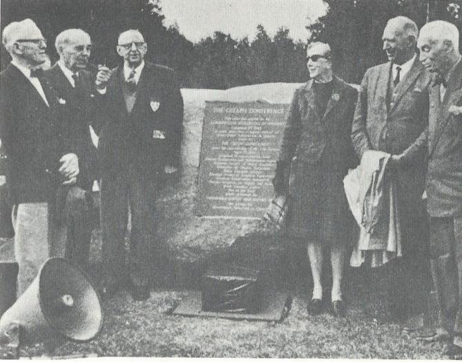
Commemorative
Memorial (1967)
- Conservation
Authorities of
Ontario
On September 27, 1967, the
Conservation Authorities of
Ontario
dedicated a special memorial
in the Garden Hill
Conservation Area nearby
Ganaraska Forest, north of
Port Hope.
The large boulder with
bronze plaque bears the
names of the nine
organizations of the Guelph
Conference and marked more
than one-quarter of a
century of conservation
achievement begun at the
Guelph
Conference.
 ` `
Conservation
by the
People:
The
History
of the
Conservation
Movement
in
Ontario
to 1970,
(1974)
A.H.
Richardson
Summary
Ganaraska
Forest is very important for
the following reasons:
the site
of
Ontario's
first
large-scale
conservation
program
on the
Oak
Ridges
Moraine;
the
initial
test
area
in
Ontario
to
demonstrate
the
benefits
of
conservation;
Ganaraska
led the
way for
the
development
of
watershed
conservation
policies
and
conservation
authorities
throughout
Ontario
and
Canada.
first
watershed
to
demonstrate
new
concepts
like the
ecosystem
approach
and
watershed
planning
(where
land-use
planning
borders
were
based on
the use
of
natural
boundaries,
rather
than
political
boundaries);
reforestation
and
other
conservation
measures
especially
on the
Oak
Ridges
Moraine
has
controlled
flooding
downstream,
particularly
in Port
Hope
where
Cameco
(formerly
Eldorado),
the
world's
largest
uranium
refinery
is
located;
Today, the
Conservation
Authorities of
Ontario are
composed of
about 38
conservation
authorities in
charge of over
400 conservation
areas.
The Conservation
Authorities of
Ontario are also
amongst Canada's
largest public
landowners.
Collectively,
the Conservation
Authorities own
and protect
approximately
144,000 hectares
(355,800 acres),
including
forests,
wetlands, areas
of natural &
scientific
interest,
recreational
lands, natural
heritage and
cultural sites
as well as land
for flood and
erosion control.
Conceived during
World War 2, the
Ganaraska Forest
was the catalyst
in the
conservation
movement in
Ontario. As a
major cultural
landscape with
distinct
cultural and
aesthetic
values, it
provides an
understanding
and appreciation
of a unique
cultural and
natural heritage
resource first
laid out in a
world recognized
conservation
plan over
seventy years
ago.
Researcher: M.
Martin
c.2014
|